-
Population in the Arctic Circumpolar Permafrost Region at settlement level, 2017
We defined permafrost settlements as settlements located within the permafrost extent, as modelled by Obu et al. (2019). The permafrost extent is based on...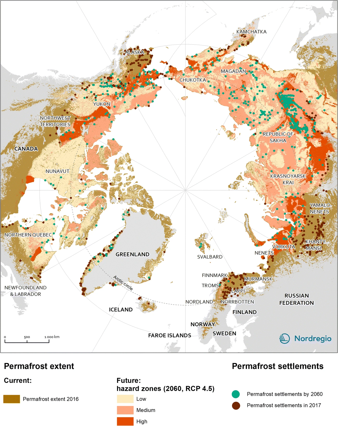
-
Settlements located within the permafrost extent in the Arctic Circumpolar Permafrost Region, 2017
We defined permafrost settlements as settlements located within the permafrost extent, as modelled by Obu et al. (2019). The permafrost extent is based on... -
Gridded monthly methane emissions from terrestrial wetlands, north of 45 °N, 2013-2014
This dataset provides wetland methane (CH4) emissions, their uncertainties and underlying CH4 flux densities north from 45 N using three different wetland maps. The data...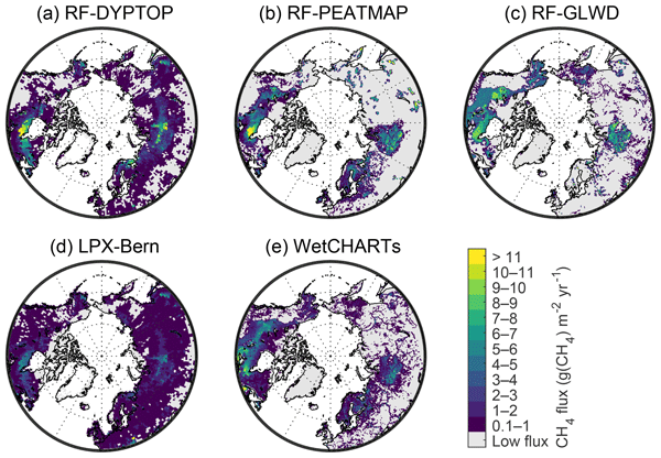
-
Incubation data, Carbon flux data and soil properties of thaw slump soils on Kurungnakh, Lena Delta, 2016 & 2019
The dataset comprises in situ CO2 and CH4 fluxes, active layer depths, thawed carbon pools and soil temperatures from different non-vegetated soils in an active thaw slump in... -
Arctic Coastal Human Impact dataset (SACHI) derived from Sentinel-1/2, 2016-2020, Circum-Arctic
The SACHI (Sentinel-1/2 derived Arctic Coastal Human Impact) V1 dataset was developed as part of the HORIZON2020 project Nunataryuk by b.geos (www.bgeos.com). V1 covered a 100km... -
Radiocarbon content of CO2, CH4, DOC and particulate organic carbon from the northern permafrost region
The dataset includes 14C measurements of CO2, CH4, DOC and POC mostly from the northern permafrost region. Some other studies are included from sites not underlained by...
-
GHG data from inverse models and UNFCCC national inventories, Global, 1990-2019
Anthropogenic greenhouse gas (carbon dioxide, methane, nitrous oxide) data from inverse models and UNFCCC national inventories This dataset contains 5 datasets, including GHG...
-
Monthly global dataset of Wetland Area and Dynamics for Methane Modeling (WAD2M) from Remote Sensing, 2000-2020
Seasonal and interannual variations in global wetland area is a strong driver of fluctuations in global methane (CH4) emissions. Current maps of global wetland extent vary with...
-
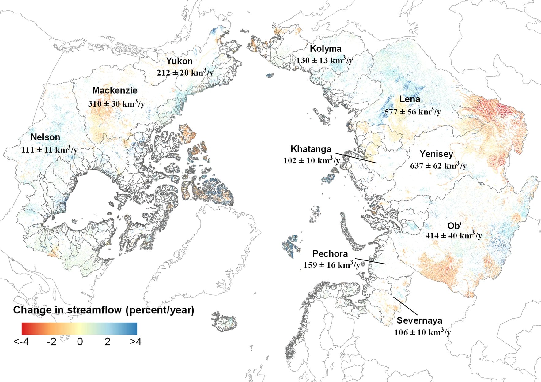
Remotely-sensed Arctic Discharge Reanalysis (RADR) from discharge observations and Landsat, 1984-2018, Circum-Arctic
Arctic rivers drain ~15% of the global land surface and significantly influence local communities and economies, freshwater and marine ecosystems, and global climate. However,...