-
Thermo-erosional valleys and streams in ice-rich permafrost lowlands from RapidEye, 2010, Buor Khaya Peninsula, Lapte...
The published data set provides an inventory of thermo-erosional landforms and streams in three lowland areas underlain by ice-rich permafrost of the Yedoma-type Ice Complex at...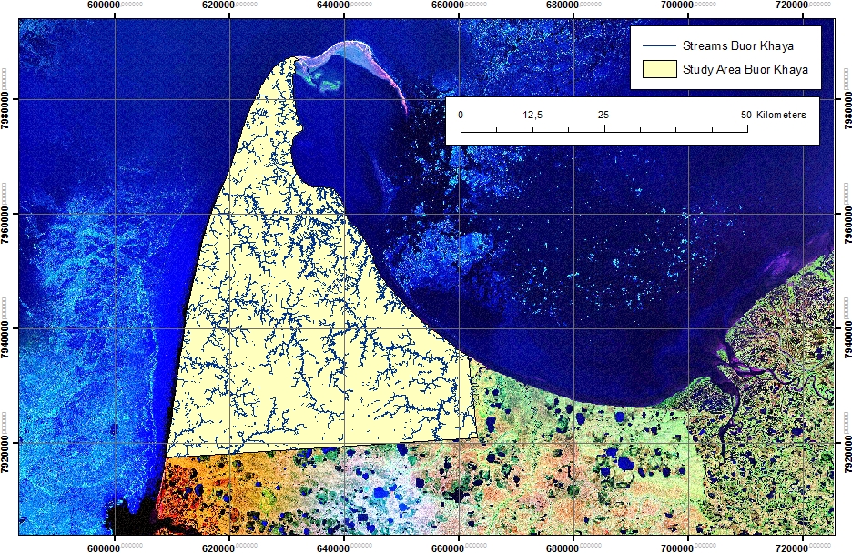
-
Thermo-erosional valleys and streams in ice-rich permafrost lowlands from Landsat, 2000, Hexagon, 1975, Lena Delta, L...
The published dataset provides an inventory of thermo-erosional landforms and streams in three lowland areas underlain by ice-rich permafrost of the Yedoma-type Ice Complex at...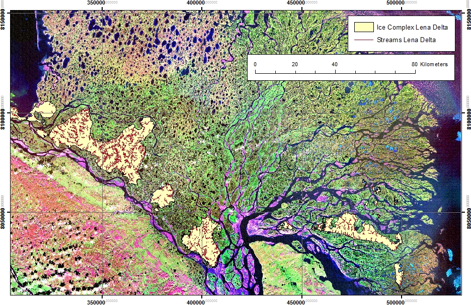
-
Thermo-erosional valleys and streams in ice-rich permafrost lowlands from Landsat, 2000, Hexagon, 1975, Cape Mamontov...
The published dataset provides an inventory of thermo-erosional landforms and streams in three lowland areas underlain by ice-rich permafrost of the Yedoma-type Ice Complex at...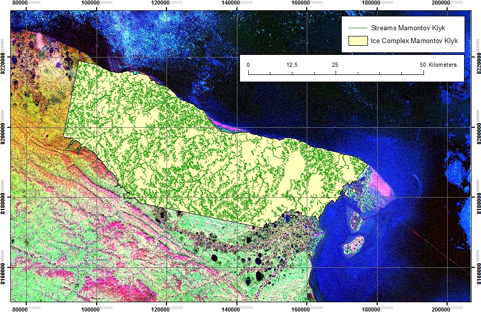
-
Potential Future Lake Drainage from an IfSAR-Derived Digital Surface Model, 2002-2003, Western Arctic Coastal Plain, ...
Assessment of lakes for their future potential to drain relied on the 2002/03 airborne Interferometric Synthetic Aperture Radar (IFSAR) Digital Surface Model (DSM) data for the...
-
Lakes from Landsat 2000-2001, Lena Delta, Laptev and East Siberian Sea Region (RU)
This data set provides a detailed inventory of lakes in the Lena Delta, northern Siberia, with respect to the lakes' association with one of the three geomorphological main...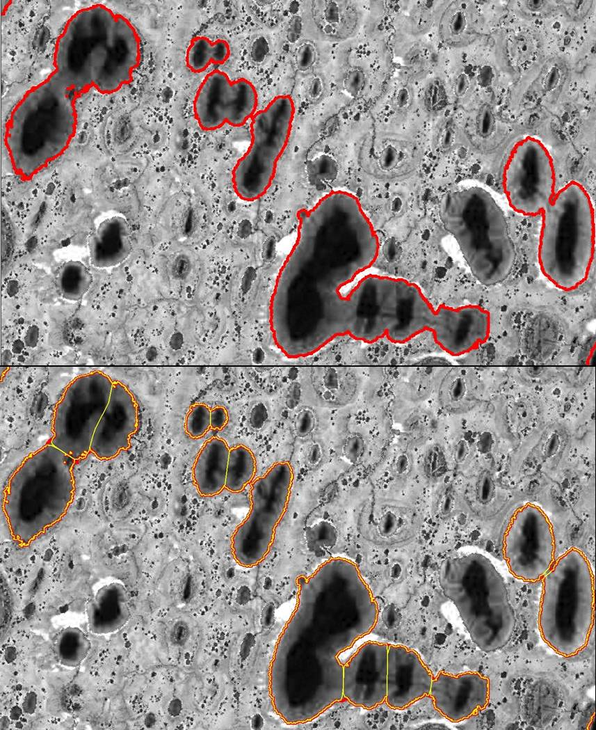
-
Trend analysis of lake dynamics from Landsat time-series 1999-2014, Alaska North Slope, Alaska (US)
The dataset was created with a methodology based on machine-learning based classification of robust trends of multi-spectral indices of Landsat data (TM,ETM+, OLI) and...
-
Trend analysis of lake dynamics from Landsat time-series 1999-2014, Kolyma Lowland, Siberia (RU)
The dataset was created with a methodology based on machine-learning based classification of robust trends of multi-spectral indices of Landsat data (TM,ETM+, OLI) and...
-
Trend analysis of lake dynamics from Landsat time-series 1999-2014, Central Yakutia, Siberia (RU)
The dataset was created with a methodology based on machine-learning based classification of robust trends of multi-spectral indices of Landsat data (TM,ETM+, OLI) and...
-
Trend analysis of lake dynamics from Landsat time-series 1999-2014, Kobuk-Selawik-Lowlands, Alaska (US)
The dataset was created with a methodology based on machine-learning based classification of robust trends of multi-spectral indices of Landsat data (TM,ETM+, OLI) and...
-
Aufeis (naleds) from 1958 historical maps and 2013-2017 Landsat-8 OLI images, Yana River basin, Siberia (RU)
The GIS database contains the data of aufeis (naled) in the Yana River basin (Russia) from historical and nowadays sources, and complete ArcGIS 10.1/10.2 and Qgis 3* projects to...
-
Remotely-sensed Arctic Discharge Reanalysis (RADR) from discharge observations and Landsat, 1984-2018, Circum-Arctic
Arctic rivers drain ~15% of the global land surface and significantly influence local communities and economies, freshwater and marine ecosystems, and global climate. However,...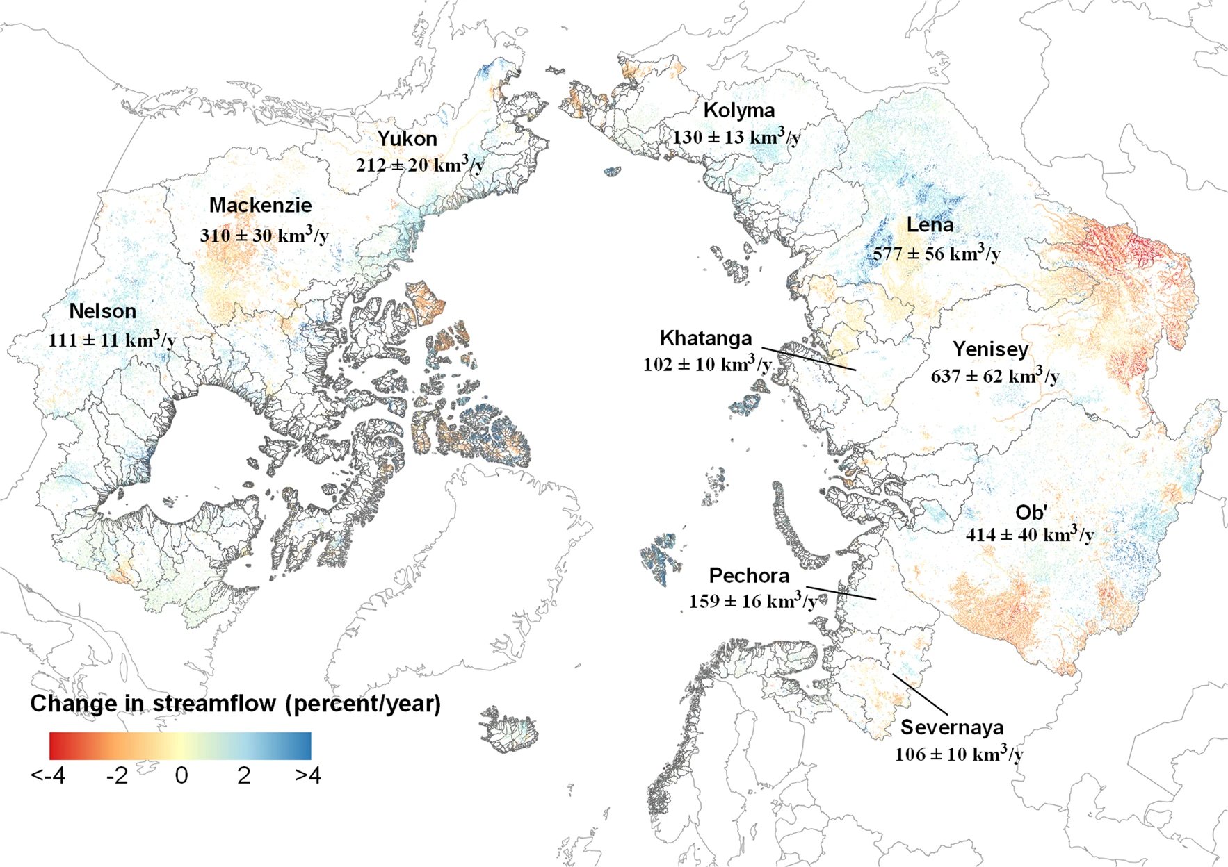
-
Quantification of shoreline movements from satellite remote sensing, 1951-2011, Yukon Territory mainland coast (CA)
The Arctic is warming, but the impacts on its coasts are not well documented. To better understand the reaction of Arctic coasts to increasing environmental pressure, shoreline...
-
Remote sensing-based permafrost region disturbances: lakes, 1999-2014, Eastern Canada (CA)
The data quantify the abundance and distribution of the permafrost region disturbance (PRD) of lakes and their dynamics, using trend analyses of 30-m-resolution Landsat imagery...
-
Remote sensing-based permafrost region disturbances: lakes, 1999-2014, Alaska (US)
The data quantify the abundance and distribution of the permafrost region disturbance (PRD) of lakes and their dynamics, using trend analyses of 30-m-resolution Landsat imagery...
-
Remote sensing-based permafrost region disturbances: lakes, 1999-2014, Eastern Siberia (RU)
The data quantify the abundance and distribution of the permafrost region disturbance (PRD) of lakes and their dynamics, using trend analyses of 30-m-resolution Landsat imagery...
-
Remote sensing-based permafrost region disturbances: lakes, 1999-2014, Western Siberia (RU)
The data quantify the abundance and distribution of the permafrost region disturbance (PRD) of lakes and their dynamics, using trend analyses of 30-m-resolution Landsat imagery...
-
Recovered Drained Thaw Lake Basins (DTLBs) from InSAR DEM and Remote Sensing Imagery, 2002-2010, Arctic Coastal Plain...
Paleoshorelines of Drained Thaw Lake Basins (DTLBs) on the Alaskan North Slope were mapped using the Interferometric Synthetic Aperture Radar Digital Elevation Model (InSAR DEM)...
-
Beaver Dam Locations from sub-meter resolution Satellite Imagery, 2010-2019, Northern Baldwin Peninsula Alaska (US)
Arctic landscapes are in a state of transition due to changes in climate occurring during both the summer and winter seasons. Scattered observations indicate that beavers...
-
Beaver Dam Locations from sub-meter resolution Satellite Imagery, 2002-2019, Kotzebue, Northwestern Baldwin Peninsula...
Arctic landscapes are in a state of transition due to changes in climate occurring during both the summer and winter seasons. Scattered observations indicate that beavers...
-
Arctic Coastal Dynamics Classification Database
An important outcome of Arctic Coastal Dynamics I was the segmentation and characterization of the entire circum-Arctic coastline by regional experts which is presented in this...
