-
Suspended particulate matter (SPM), Total particulate carbon (TPC) and Total particulate nitrogen (TPN) concentration...
Material for the determination of suspended particulate matter (SPM), total particulate carbon (TPC) and total particulate nitrogen (TPN) was obtained by filtering 300-700 mL...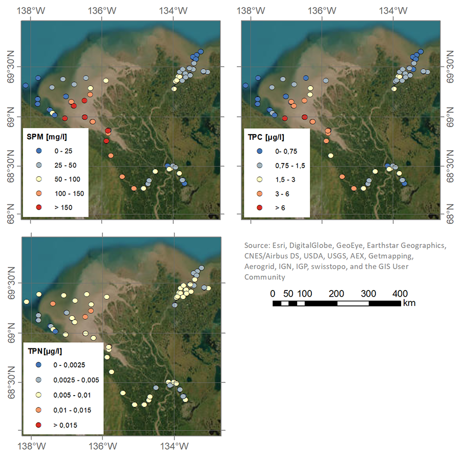
-
Nutrient (NO3, NO2, PO4, SiO4) concentrations in the surface water during 4 expeditions from spring to fall in 2019, ...
Water for nitrate (NO3), nitrite (NO2), phosphate (PO4) and silicate (SiO4) was filtered using an acid-washed 60-mL luer-lock syringe combined with an Acrodisc filter (GF/F 0.7...
-
Isotopic composition of ground ice, ebullition gases and thermokarst lake water, Alaska, 2008-2010
Thermokarst lakes are thought to have been an important source of methane (CH4) during the last deglaciation when atmospheric CH4 concentrations increased rapidly. Here we...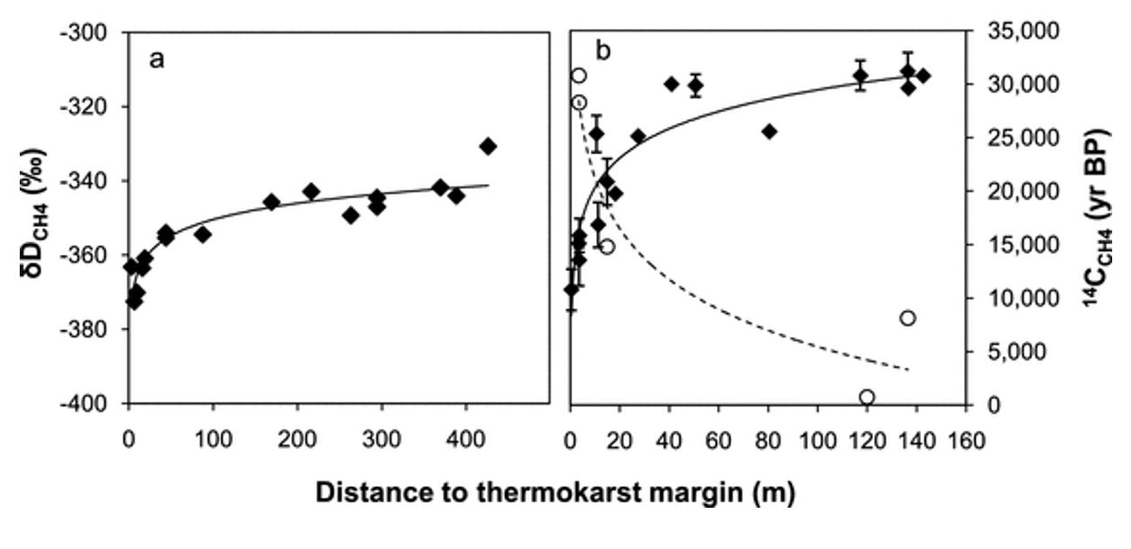
-
Methane and nitrous oxide dissolved gas concentrations in seawater from the North American Arctic Ocean (2015–2018)
This dataset contains methane and nitrous oxide dissolved gas concentration, dissolved methane carbon isotope, and ancillary hydrographic data from research cruises in the North...
-
Methane and nitrous oxide dissolved gas concentrations from rivers in the North American Arctic (2017–2019)
This dataset contains methane and nitrous oxide dissolved gas concentration and dissolved methane carbon isotope data from rivers in the Canadian Arctic Archipelago region...
-
Land Surface Feature Classification from TerraSAR-X, 2013, Lena Delta, Laptev and East Siberian Sea Region (RU)
Land surface features (water, wetland, tundra, and bare surfaces) were classified from TerraSAR-X with a resolution of 5 m for August 2012 and July 2014. The product is based on...
-
Chamber methane fluxes with spectrometer from a polygon tundra, 2015, northeastern Siberia
This dataset contains in situ CH4 fluxes measured through the chamber technique over the growing season of 2015 (from July to September) at a wet polygon center and a dry... -
Wetland maps including open water extent dynamics based on ENVISAT ASAR WS for Siberia, 2007 and 2008
Wetlands store large amounts of carbon, and depending on their status and type, they release specific amounts of methane gas to the atmosphere. The connection between wetland...
-
Dataset of a globally relevant stock of soil nitrogen in the Yedoma permafrost domain, 1998-2016, Circum-Arctic
This dataset merges nitrogen data from the Yedoma domain. It includes numerous fieldwork campaigns, which take place since 1998. In total 467 samples from the active layer...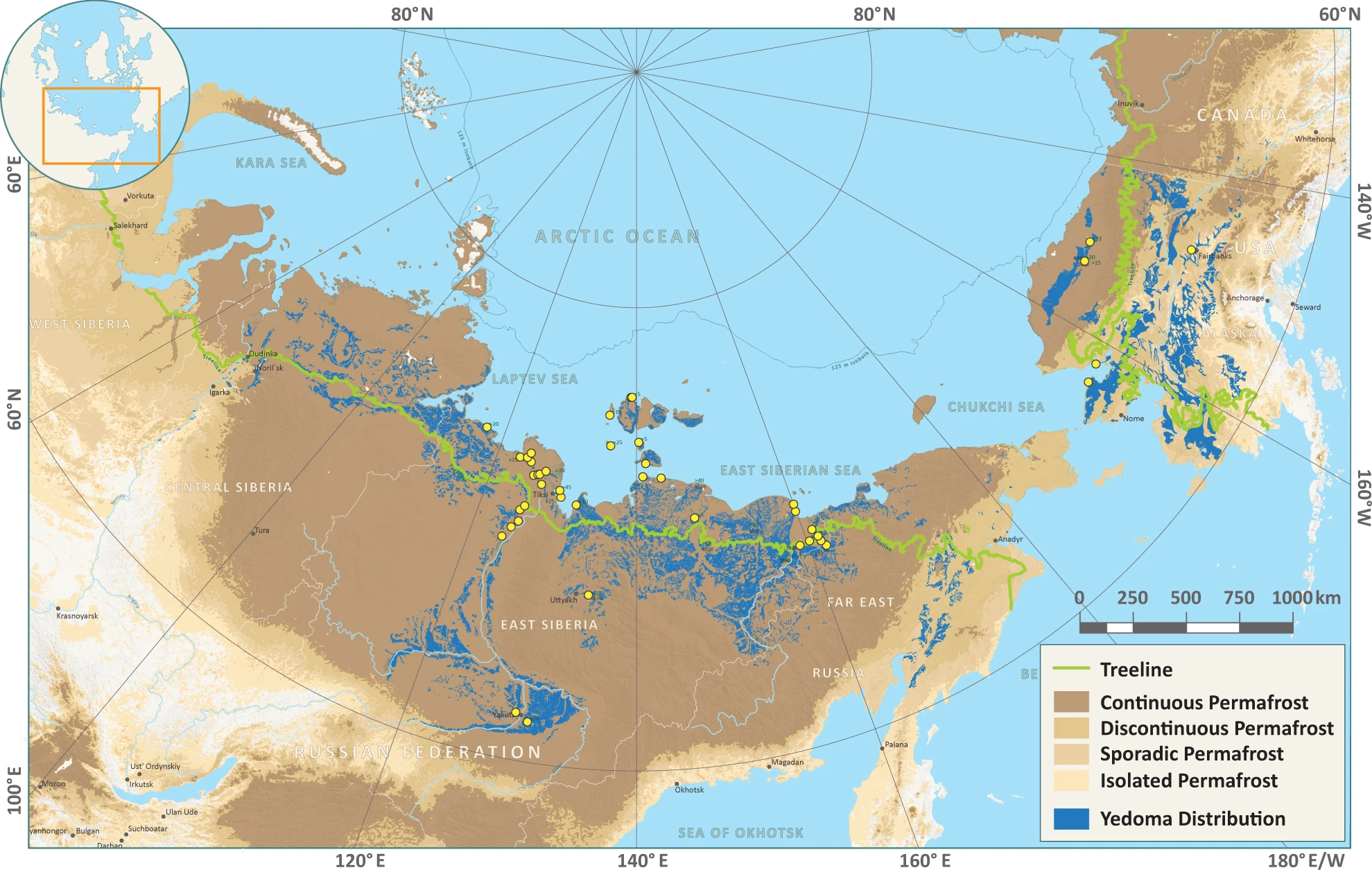
-
Circumarctic wetland dataset based on ENVISAT ASAR Global Monitoring Mode, 2005-2011, Panarctic
A circumpolar representative and consistent wetland map is required for a range of applications ranging from upscaling of carbon fluxes and pools to climate modelling and...
-
Vegetation map of Trail Valley Creek from airborne orthophotos, laser scanning and field work data, Northwest Territo...
The vegetation map distinguishes between five tundra vegetation types, trees, and open water at the forest-tundra transition north of Inuvik, Northwest Territories, Canada. The...
-
Land cover classification of tundra environments from Landsat, 2000-2001, Lena Delta, Laptev Sea Region (RU)
The study was based on land cover classification of three almost cloud free Landsat-7 ETM+ satellite images. The acquisition dates are 27 July 2000 (path 131, rows 8 and 9) and...
-
Aufeis (naleds) from 1958 historical maps and 2013-2017 Landsat-8 OLI images, Indigirka River basin, Siberia (RU)
The GIS database contains the data of aufeis (naleds) in the Indigirka River basin (Russia) from historical and nowadays sources, and complete ArcGIS 10.1/10.2 and Qgis 3*...
-
Aufeis (naleds) from 1958 historical maps and 2013-2019 Landsat-8 OLI images, Chukotka region, Siberia (RU)
The GIS database contains the data of aufeis (naled) in the Chukotka region from historical and nowadays sources, and complete ArcGIS 10.1/10.2 and Qgis 3* projects to view and...
-
Aufeis (naleds) from 1958 historical maps and 2013-2017 Landsat-8 OLI images, Kolyma River basin, Siberia (RU)
The GIS database contains the data of aufeis (naleds) in the Kolyma River basin (Russia) from historical and nowadays sources, and complete ArcGIS 10.1/10.2 and Qgis 3* projects...
-
Lake-DOC Database (PeRL-DOCv1), 1979-2017, Permafrost-Region
The pan-Arctic Permafrost-Region Lake-DOC version1 database contains surface water samples of lakes in the permafrost regions of Alaska (49.3 %), Canada (24.2 %), Greenland (3.2...
-
Distribution of pingos from an IfSAR digital surface model, 2002-2006, western Arctic Coastal Plain, Northern Alaska ...
A detailed attributed point feature shapefile of 1247 pingo locations was manually assembled from a 5m resolution digital surface model (DSM) derived from an airborne...
-
Distribution of pingos from topographic maps, permafrost region, Siberia (RU)
A detailed attributed point feature shapefile of 6059 pingo locations in a 3.5 × 10⁶ km² region of northern Asia was manually assembled from 1:200 000 scale Russian...
-
GTN-P (2015): Global Terrestrial Network for Permafrost metadata for permafrost boreholes (TSP) and active layer moni...
The Global Terrestrial Network for Permafrost (GTN-P) provides the first dynamic database associated with the Thermal State of Permafrost (TSP) and the Circumpolar Active Layer...
-
Database of Global Peatland Extent and Carbon Stocks through the Last Glacial Cycle (130 ka to present)
We present the first synthesis of global peatland extent through the last glacial cycle (130 ka) based on >975 detailed stratigraphic descriptions from exposures, soil pits,...
